


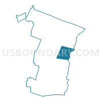
Hartland Voting District, Windsor County, Vermont
About
Outline

Summary
| Unique Area Identifier | 680948 |
| Name | Hartland Voting District |
| County | Windsor County |
| State | Vermont |
| Area (square miles) | 45.20 |
| Land Area (square miles) | 44.89 |
| Water Area (square miles) | 0.31 |
| % of Land Area | 99.31 |
| % of Water Area | 0.69 |
| Latitude of the Internal Point | 43.58054850 |
| Longtitude of the Internal Point | -72.43886700 |
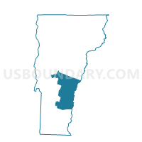
Maps

Graphs
Select a template below for downloading or customizing gragh for Hartland Voting District, Windsor County, Vermont


Neighbors
Neighoring Voting District (by Name) Neighboring Voting District on the Map
- Hartford District 1, Windsor County, VT
- Hartford District 2, Windsor County, VT
- LEBANON WARD 1, Grafton County, NH
- TOWN OF PLAINFIELD Voting District, Sullivan County, NH
- West Windsor Voting District, Windsor County, VT
- Windsor Voting District, Windsor County, VT
- Woodstock Voting District, Windsor County, VT
Top 10 Neighboring County Subdivision (by Population) Neighboring County Subdivision on the Map
- Lebanon city, Grafton County, NH (13,151)
- Hartford town, Windsor County, VT (9,952)
- Windsor town, Windsor County, VT (3,553)
- Hartland town, Windsor County, VT (3,393)
- Woodstock town, Windsor County, VT (3,048)
- Plainfield town, Sullivan County, NH (2,364)
- West Windsor town, Windsor County, VT (1,099)
Top 10 Neighboring Place (by Population) Neighboring Place on the Map
Top 10 Neighboring Elementary School District (by Population) Neighboring Elementary School District on the Map
- Hartland School District, VT (3,393)
- Woodstock School District, VT (3,048)
- Plainfield School District, NH (2,364)
- West Windsor School District, VT (1,099)
Top 10 Neighboring Secondary School District (by Population) Neighboring Secondary School District on the Map
Top 10 Neighboring Unified School District (by Population) Neighboring Unified School District on the Map
- Lebanon School District, NH (13,151)
- Hartford School District, VT (9,952)
- Windsor School District, VT (3,553)
Top 10 Neighboring State Legislative District Lower Chamber (by Population) Neighboring State Legislative District Lower Chamber on the Map
- State House District 11, Grafton County, NH (13,151)
- Windsor-6-2 State House District, VT (7,992)
- State House District 1, Sullivan County, NH (6,989)
- Windsor-4 State House District, VT (4,492)
- Windsor-6-1 State House District, VT (3,811)
- Windsor-5 State House District, VT (3,714)
- Windsor-3 State House District, VT (3,553)
Top 10 Neighboring State Legislative District Upper Chamber (by Population) Neighboring State Legislative District Upper Chamber on the Map
Top 10 Neighboring 111th Congressional District (by Population) Neighboring 111th Congressional District on the Map
Top 10 Neighboring Census Tract (by Population) Neighboring Census Tract on the Map
- Census Tract 9618, Grafton County, NH (5,579)
- Census Tract 9656, Windsor County, VT (4,143)
- Census Tract 9751, Sullivan County, NH (4,004)
- Census Tract 9660, Windsor County, VT (3,553)
- Census Tract 9657, Windsor County, VT (3,393)
- Census Tract 9659, Windsor County, VT (3,320)
- Census Tract 9658, Windsor County, VT (3,048)
- Census Tract 9655.01, Windsor County, VT (2,998)
Top 10 Neighboring 5-Digit ZIP Code Tabulation Area (by Population) Neighboring 5-Digit ZIP Code Tabulation Area on the Map
- 05001, VT (9,123)
- 05089, VT (4,979)
- 03784, NH (4,086)
- 05091, VT (3,288)
- 05048, VT (2,429)
- 03781, NH (1,840)
- 05059, VT (874)
- 05052, VT (348)
- 05071, VT (324)